Here is the snip of the Truxton Circle area of the “Recommended Amendments to the DC Comprehensive Plan Future Land Use Map (FLUM)” from this link:
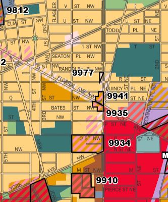
You see the four-digit tracking codes on the map snip above?
I have snipped the entries for the above tracking codes for Truxton Circle.
You will need to click on the image below to actually read it, since it is a multi-column spreadsheet with tiny type.
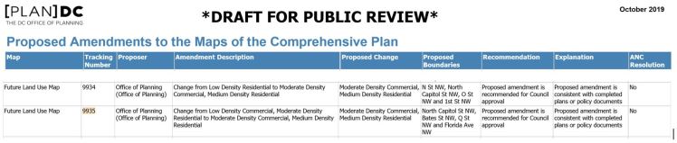
So for the area bounded by “N St NW, North Capitol St NW, O St NW and 1st St NW”, the proposed amendment is “Change from Low Density Residential to Moderate Density Commercial, Medium Density Residential”,
For the area bounded by “North Capitol St NW, Bates St NW, Q St NW and Florida Ave NW”, the proposed DC Comprehensive Plan amendment is “Change from Low Density Commercial, Moderate Density Residential to Moderate Density Commercial, Medium Density Residential.”
What do you think ?

Wait that includes Joe Mamo’s lot.